I recently saw this excellent graphic linked on a message board and thought it was worth sharing (thanks to Bob Sherman in SC for posting it!).

http://www.carolana.com/SC/Royal_Colony/the_great_wagon_road.html

The course of the Wilderness Road by 1785 Wikipedia

National Park Service, Cumberland Gap National Historical Park
Portions of the road labelled "Wilderness Road to Tennessee" date from the 1760-61 Virginia Provincial Cherokee campaign's protected advance to Fort Chiswell (Wythe County), Stalnaker's Plantation (Chilhowie, where Fort Attakullakulla was built), and the finally the Virginia built Fort at the Big Island on the Holston (Kingsport Tennessee). These frontier roads eventually become part of the "Wilderness road"; the overland route to Kentucky through the Cumberland gap.
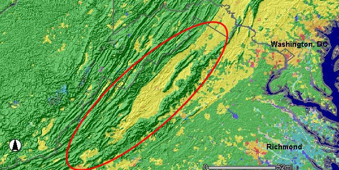
The topographic view above illustrates the physical realities and natural barriers of road travel to the backcountry in the 18th century and should explain how and why so many people and goods from Pennsylvania flowed to western Virginia and North Carolina in the 18th century along that route.

Original Conestoga Wagon at the Smithsonian Institution
For some fantastic information on manufactured goods moving from Pennsylvania to North Carolina, (and a nod to the "Clothing the Carolinas" Blog for posting the link) see the William Sample Alexander Diary, 1770-1778. William Sample Alexander operated a wagon train between Mecklenburg County and Chester County, Pa.
A generalized discussion of topography and it's effect on Virginia settlement patterns can be seen here:
http://www.virginiaplaces.org/geology/topo.html
When 18th century people said they were heading 'up' the Shenandoah Valley, they meant moving south:
http://www.southernspaces.org/2004/shenandoah-valley for further reading I highly recommend this book:
http://books.google.com/books/about/The_Planting_of_New_Virginia.html?id=guS_QwTKdp8C
In the late 18th century Benjamin Rush discussed this phenomenon. His somewhat stilted take can be found in the link below and contains some great info on early settlement:
http://books.google.com/books?id=xtUKAAAAIAAJ&pg=PA213&dq=An+Account+of+the+Progress+of+Population,+Agriculture,+Manners+and+Government+in+Pennsylvania&hl=en&ei=J2XVTePfIMfr0gHDv9T5Cw&sa=X&oi=book_result&ct=result&resnum=1&ved=0CCoQ6AEwAA#v=onepage&q=An%20Account%20of%20the%20Progress%20of%20Population%2C%20Agriculture%2C%20Manners%20and%20Government%20in%20Pennsylvania&f=false
Another excellent graphic addressing roads in the period can be found here:

http://www.carolana.com/SC/Royal_Colony/all_primary_roads_royal_period.html